
Terrestrial Exploration of the Cunca Wulang Canyon in Labuan Bajo
The western coast of Flores Island is globally recognized as the primary gateway to the Komodo National Park, a marine paradise celebrated for its rich underwater biodiversity and iconic endemic wildlife. However, the interior highlands of the West Manggarai Regency hide terrestrial treasures that rival the beauty of the coast. Among these inland marvels, the river canyon known as Air Terjun Cunca Wulang Labuan Bajo stands as a premier destination for adventurous international travelers who seek physical challenge and pristine natural environments. Orchestrated as part of the broader ecotourism initiative supported by premier expedition organizations such as the Seven Seas Group, whose digital portal at thesevenseasg.com serves as a guide for luxury maritime and overland travel, Cunca Wulang presents a dynamic confluence of geological history, regional folklore, and ecological conservation.
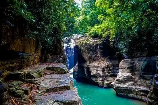
Geological Architecture of the Wae Ranteng Gorge
Although often referred to in promotional materials as a waterfall, Cunca Wulang is structurally a narrow river canyon formed by the systematic incision of limestone karst over geological epochs. The primary force behind this landscape is the Wae Ranteng river, which flows forcefully through the region before entering subterranean channels downstream. Over millions of years, the hydraulic action of the river has carved a deep, winding fissure in the limestone, leaving vertical rock walls that rise up to ten meters above the water surface. This spectacular topography has earned the site its reputation as a miniature Grand Canyon of Flores, mirroring the majestic erosion patterns of much larger global landforms on a beautifully condensed scale.
At an elevation of approximately 200 meters above sea level, the local atmosphere is notably cooler and more refreshing than the humid coastal plains of Labuan Bajo. The main cascade occurs where the river forces its way through narrow stone gaps, plunging into deep natural basins carved directly into the bedrock. These limestone shelves create multiple levels of freshwater pools that vary in depth, presenting ideal conditions for technical river trekking, swimming, and controlled cliff jumping.
Hydrological Dynamics and Seasonal Fluctuations
The physical character, safety profile, and aesthetic appeal of the canyon are directly governed by the regional monsoonal cycles of East Nusa Tenggara. This seasonality is a crucial factor for international explorers planning their itineraries through the Seven Seas Group.
During the dry season, which generally extends from April to October, the water levels of the Wae Ranteng river recede, exposing the sculpted limestone foundations of the gorge. With reduced flow velocity, suspended particulate matter settles, transforming the river pools into a striking, vibrant turquoise hue. This period represents the safest and most visually spectacular window for visitors, offering optimal conditions for swimming, underwater photography, and navigating the narrow stone passages.
Conversely, the wet season, spanning from November to March, introduces a dramatic shift in the hydrological environment. Heavy tropical precipitation in the highland catchment areas causes rapid increases in river volume and current speed. The water carries a heavy load of clay and organic sediments washed from the surrounding forest soils, turning the turquoise pools into a turbid, chocolate brown torrent. During periods of intense rainfall, the river can rise above the lower boulders, rendering the canyon floor inaccessible and making swimming and cliff jumping highly hazardous due to powerful underwater currents and floating debris.
The Highland Forest Trail and Agrarian Landscapes
The physical journey to the canyon begins at the highland settlement of Wersawa Village, also spelled Wersawe in regional records, situated about 30 kilometers east of Labuan Bajo. This starting point provides travelers with an engaging transition from managed agrarian landscapes to undisturbed tropical rainforest.
The initial portion of the walking trail winds through lush, local agricultural plots managed by the highland Manggarai communities. Visitors can observe a diverse array of tropical cash crops growing in harmony with the natural canopy, including vanilla vines climbing supporting trunks, shade grown coffee shrubs, candlenut trees, and valuable cacao plants. This agricultural buffer illustrates the self sustaining nature of the highland communities and provides an educational overview of traditional Indonesian farming techniques before entering the wild forest.
Upon crossing into the forest boundary, the path descends steeply into a dense tropical rainforest ecosystem characterized by high humidity and thick canopy cover. The trail features a series of concrete steps, natural dirt pathways, and two suspended rope bridges that cross the river gorges safely. Because of the damp forest floor and decaying leaf litter, the rocks along the path can become highly slippery, requiring sturdy hiking footwear with reliable grip.
An interesting ecological feature of this damp forest environment is the presence of giant forest earthworms. These organisms construct large, prominent soil towers known as turricules from the leaf litter. These structures are a testament to the high soil health and active decomposition processes within the Flores rainforest, playing a vital role in nutrient cycling that supports the surrounding flora.
The Subterranean Channel of Liang Rodak
While the surface waters of the canyon draw the most attention, the hydrological system of Cunca Wulang features an extraordinary subterranean extension located roughly one kilometer downstream from the main pools. At this junction, the Wae Ranteng river, which expands to a width of approximately ten meters, plunges directly into a limestone cave system known as Liang Rodak.
The Liang Rodak cave represents a continuous underground passage stretching for approximately two kilometers. Complete navigation of this subterranean river remains impossible due to a powerful hydraulic vortex that forms inside the narrow chambers of the cave, posing a fatal threat to any unauthorized entry. However, travelers seeking a unique speleological experience can arrange to explore the mouth of Liang Rodak Cave. This specialized trek requires a dedicated fee of IDR 150,000 to secure two local village rangers who possess the technical knowledge required to navigate the entrance safely, monitoring water levels and currents to ensure visitor security.
Cultural Heritage and Ecotourism Governance
The physical beauty of the Cunca Wulang canyon is deeply intertwined with the spiritual history of the Manggarai people. Local community folklore dictates that the circular, moon shaped spring at the summit of the canyon is a sacred site. According to traditional beliefs, this spring is protected by a spiritual guardian known as Empo Cunca Wulang. This spiritual connection has historically fostered a deep respect for the surrounding wilderness, helping to preserve the pristine nature of the canyon for generations.
This terrestrial adventure is frequently paired with a cultural excursion to Melo Village, a traditional mountain settlement that offers panoramic views over the Labuan Bajo coastline. In Melo Village, visitors can witness the Caci whip dance, a traditional Manggarai performance symbolizing masculinity, respect, and tribal bravery. Dancers wearing traditional headwear strike each other with leather whips while defenders use rattan shields, creating a captivating display of rhythmic movement and physical endurance.
To manage the environmental impact and support local livelihoods, the community has established a structured ecotourism framework. All visitors are required to register at the Wersawa village office and hire a local village ranger to accompany them down to the canyon. This mandatory system ensures that the economic benefits of tourism flow directly back to the agrarian community of Wersawa, funding local infrastructure, trail maintenance, and conservation efforts while providing travelers with expert safety supervision.
Sustainable Tourism Integration and Overland Operations
The Seven Seas Group, highly regarded for its luxury maritime expeditions and liveaboard voyages throughout the Indonesian archipelago, places a strong emphasis on sustainable tourism that balances marine adventures with terrestrial exploration. While marine destinations such as Manta Point, Pink Beach, and Padar Island remain central to the Komodo experience, terrestrial journeys like the Cunca Wulang canyon expedition provide essential economic balance for the mainland communities of Flores.
By encouraging overland travel to the West Manggarai highlands through their digital platform at thesevenseasg.com, the Seven Seas Group helps distribute tourism revenue to inland villages that do not directly benefit from coastal marine charters. This approach aligns with modern ecological conservation goals by reducing visitor density on fragile coral reefs while providing travelers with a comprehensive, multi dimensional understanding of Flores Island.
Practical Logistics and Travel Information
To facilitate a successful expedition, travelers should familiarize themselves with the financial, logistical, and preparation requirements associated with the Cunca Wulang canyon trail.
Summary of Terrestrial Exploration Expenses
The table below outlines the standard operational costs associated with accessing the canyon and surrounding geological features.
Expense Category | Cost in Indonesian Rupiah | Description and Inclusions |
Individual Entry Ticket | 20000 to 25000 | Standard government conservation fee per person |
Local Ranger Guide Fee | 50000 to 100000 | Required ranger guide for trail safety and navigation |
Combined Entry and Guide Package | 100000 | Standard baseline individual package price |
Liang Rodak Ranger Fee | 150000 | Guided cave mouth exploration with two rangers |
Daily Scooter Rental | 75000 | Standard independent transit rate excluding fuel |
Private Car Rental with Driver | 650000 | Ten hour daily rental rate for group transport |
Essential Preparation and Safety Guidelines
To ensure a safe and comfortable trek through the highland rainforest, visitors should observe the following guidelines based on local ranger recommendations
Footwear and Gear High traction water shoes or sturdy hiking sandals with secure straps are essential due to the slippery limestone steps and damp trails. Travelers should also pack a high quality waterproof dry bag to protect electronic equipment during river swims.
Hydration and Nutrition Because the trail features a steep climb on the return leg, carrying an adequate supply of drinking water is critical. Only a very basic stall operates near the canyon, selling instant coffee and light snacks, meaning comprehensive nutrition must be brought from Labuan Bajo.
Cliff Jumping Protocols Jumping from the limestone cliffs into the deep pools is a highly popular activity, with platforms ranging from three to ten meters in height. However, water depths can fluctuate rapidly, and submerged logs or rocks may shift after heavy rains. Travelers must always obtain explicit clearance from their accompanying village ranger before making any jump.
Optimal Timing The ideal arrival window is between nine in the morning and one in the afternoon, allowing for maximum sunlight exposure inside the narrow canyon walls. Visitors should avoid arriving after three in the afternoon, as safety regulations restrict swimming after five in the evening to prevent emergency situations after nightfall.